 |
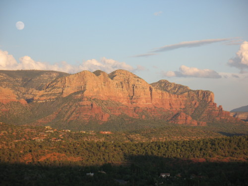
| The Mermaid at moonrise, from Red Rock Loop Road |
Honestly, you can find stirring scenery in Sedona, Arizona, without getting in a car and driving around. But spring is here, complete with wildflowers, busy birds, and blue skies, and one of the best ways to take it all in is with a scenic drive. Here are my favorites:
1. Red Rock Scenic Byway
This 7.5-mile “All American Road” is Sedona’s main gateway,
State Route 179 from I-17 through the Village of Oak Creek. Officially, Red Rock Scenic Byway begins at milepost 302, where SR 179 crosses Dry Beaver Creek. Like many “creeks”
in Arizona, this one is a rocky wash except during spring runoff, but even when
dry it’s delineated by tall cottonwoods and white-trunked Arizona sycamores. A couple miles further, the new forest service visitor center is an ideal place to stop to pick up trail maps and a Red
Rock Pass, as well as take a long look at the panorama ahead. The view
encompasses Bell Rock, Courthouse Butte, and other brilliantly colored cliffs.
In recent years, SR 179 has been widened to a divided four-lane highway, with scenic pullouts and ample trailhead parking. The
designated scenic byway ends at milepost 310, near the celebrated Chapel of the
Holy Cross, but the scenery doesn’t quit. SR 179 passes along Sedona’s “gallery
row,” including the creekside shops at Tlaquepaque, before ending at “the Y,” a
double-roundabout intersection with SR 89A.
2. Red Rock Loop Road
Travelers entering Sedona from the west via SR
89A can turn right at milepost 368 for Lower Red Rock Loop Road, the beginning of a scenic 7-mile
long side trip that skirts the base of 4,899-foot Scheurman Mountain before
circling back to rejoin the highway. Though a short section of the loop is
gravel, the route is accessible to most passenger cars, depending on
weather.
The loop road edges Oak Creek, where some of the
Sedona area’s first settlers lived. The Schuerman homestead is preserved at Red Rock State Park, at mile 3 along the loop. The park offers great creekside
birdwatching and easy hiking trails with great views. covered sandstone cliffs.
Don’t miss the side-trip to Crescent Moon Ranch
picnic area and Red Rock Crossing. At the stop sign, turn onto Chavez Ranch
Road and follow the signs. The spires of majestic Cathedral Rock soar above and
reflect in the clear waters of Oak Creek, an inspiring scene said to be the
most photographed place in Arizona.
The loop road climbs a series of hairpin turns before
passing Red Rock High School and rejoining SR 89A. Dirt pullouts are good
places to stop for breath-taking elevated views of Cathedral Rock and
Courthouse Butte.
3. Boynton Pass Loop
A visit to Sedona’s backcountry, where you’ll find
hiking trails and prehistoric ruins, begins by turning north on Dry Creek Road
from SR 89A. Turn left at the next two T-intersections. (A right at the second
T leads to the acclaimed Enchantment Resort and trailhead parking for Boynton
Canyon, considered a vortex site.) The Boynton Pass Road (FR 152C) is paved
to the Bear Mountain/Doe Mesa trailhead. Depending on weather conditions, most
passenger cars can handle the dirt road beyond, which ends at FR 525, Red
Canyon Road. Turn right, and you’ll come to a fork. To the left is the bumpy
4.5-mile route to Honanki ruins (high-clearance recommended). The 2-mile
gravel road on the right leads to Palatki Heritage Site, home to a
900-year old dwelling built into the cliffs of Red Canyon by the Sinagua Indians. With a reservation, you can hike to the ruin overlook or take a
guided tour through rock alcoves marked with thousands of pictographs and
petroglyphs. Palatki and nearby Honanki are maintained by Coconino National Forest. To complete the loop after
leaving Palatki, stay on Red Canyon Road for 10 miles until it connects with SR
89A.
BONUS: Schnebly Hill Road
Schnebly Hill Road winds up to the Mogollon Rim,
following a historic route that early settlers used to reach Flagstaff, then a trip of
2-4 days. The views are amazing, but after the first mile, the dirt
road is primitive and rocky. Unless you have a high-clearance vehicle, it’s
best to see this one by signing up for a jeep tour or on foot via the Munds Wagon Trail, a 4-mile hiking trail that parallels the road. The trailhead
has ample parking, picnic tables, and panoramic views of Uptown Sedona. Whether behind the wheel or on foot, stop to admire the Cow Pies, mounds of red sandstone (another vortex, say some) with outstanding views that take in Sedona and the Verde Valley. Schnebly Hill Road begins at the Oak Creek Bridge roundabout, next to Sedona
Pottery.