Showing posts with label Red Rock State Park. Show all posts

Sunday, April 29, 2012

Sedona is for the Birds


Last night, while I was making pizza to the sounds of Mozart, a warbling song drifted in through the open windows. In the deep twilight, I couldn’t identify the singer by sight, but it seemed like the bird was responding to the violins playing on the stereo. Spring has brought a symphony of birdsong to our backyards and “neighborwoods,” the local nickname for the Coconino National Forest boundary that encircles Sedona.

Being so close to national forest, we host a mix of species, shy spotted towhees shuffling beneath bushes in search of insects, scrub jays scolding loudly from pinons, the occasional kestral silently watching for rodents or smaller birds from a branch or telephone pole. A popular neighborwoods walk is to climb Sugarloaf, a red sandstone butte in West Sedona, where white-throated swifts zoom past hikers’ heads.

Deeper in the forest, the liquid song of the canyon wren is sweet music to hikers' ears. These small reddish-brown wrens (about five inches long) hop in and out of rocky crevices and boulder piles in search of insects. The male’s song is a descending, flutelike tew-tew-tew-tew-tew-tew. Females usually choose nest sites hidden in the rocks, though one little mother raised her brood inside the room of an ancient cliff dwelling at Palatki. She tucked her nest in the hole from a roof beam, and her four offspring grew up under the watchful eyes of the site’s rangers and hundreds of visitors.
Cliffs and ledges in Fay Canyon, Sedona

Rocky canyons like Fay, Boynton, and Long also echo with the piercing cries of hawks and peregrine falcons, a threatened and endangered species (TES). Peregrines nest on the ledges of Sedona’s famed rock formations—the second highest concentration of breeding pairs in the state. Where canyons climb to higher elevations, acorn woodpeckers drill holes in ponderosa trunks to store row upon row of acorns, then spend most of their time relocating and defending their accumulated wealth. (Nature’s metaphor for modern life, perhaps?)

With nearly two hundred avian species, from tiny black-chinned hummingbirds to bald eagles, Sedona is a paradise for birdwatchers. Most birds nest here during summer, then spend winter months in Mexico or Central and South America. Seventeen are on the TES list, many of these—including the Southwestern willow flycatcher and belted kingfisher—dependent on riparian areas, the lush environments of Oak Creek, Beaver Creek, or the Verde River.

Some of the best places for birdwatching near Sedona are Red Rock State Park, the wetlands (reclamation ponds) west of town, or the Page Springs Fish Hatchery. Today is the final day of the area's top nature-themed event, the Verde Valley Birding and Nature Festival held each April. Whether you're an experienced birder or a beginner hoping to learn a little more about the feathered musicians in your backyard, the "Birdy Verde" is a fabulous event with workshops and guided field trips throughout central and northern Arizona.

Being a naturalist wannabe, I've made an effort over the years to study Sedona's flora and fauna. And yet every spring I find myself needing to relearn birdcalls or distinguishing marks. Binoculars sit by windows, and field guides pile up on shelves and tables along with a notebook and pen. After hearing last night's anonymous warbler, however, I've decided it's okay to remain in appreciative ignorance. Sometimes, not knowing can be sweeter. As psychologist Eric Berne once said, 
"The moment a little boy is concerned with which is a jay and which is a sparrow, he can no longer see the birds or hear them sing."  
As a writer who travels, I'm often too quick to put a label on the things I see. Sometimes it's better simply to enjoy them.

Friday, March 30, 2012

Sedona's Top 3 Scenic Drives

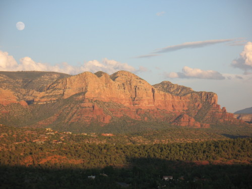
The Mermaid at moonrise, from Red Rock Loop Road

Honestly, you can find stirring scenery in Sedona, Arizona, without getting in a car and driving around. But spring is here, complete with wildflowers, busy birds, and blue skies, and one of the best ways to take it all in is with a scenic drive. Here are my favorites: 

1. Red Rock Scenic Byway
This 7.5-mile “All American Road” is Sedona’s main gateway, State Route 179 from I-17 through the Village of Oak Creek. Officially, Red Rock Scenic Byway begins at milepost 302, where SR 179 crosses Dry Beaver Creek. Like many “creeks” in Arizona, this one is a rocky wash except during spring runoff, but even when dry it’s delineated by tall cottonwoods and white-trunked Arizona sycamores. A couple miles further, the new forest service visitor center is an ideal place to stop to pick up trail maps and a Red Rock Pass, as well as take a long look at the panorama ahead. The view encompasses Bell Rock, Courthouse Butte, and other brilliantly colored cliffs.

In recent years, SR 179 has been widened to a divided four-lane highway, with scenic pullouts and ample trailhead parking. The designated scenic byway ends at milepost 310, near the celebrated Chapel of the Holy Cross, but the scenery doesn’t quit. SR 179 passes along Sedona’s “gallery row,” including the creekside shops at Tlaquepaque, before ending at “the Y,” a double-roundabout intersection with SR 89A.

2. Red Rock Loop Road
Travelers entering Sedona from the west via SR 89A can turn right at milepost 368 for Lower Red Rock Loop Road, the beginning of a scenic 7-mile long side trip that skirts the base of 4,899-foot Scheurman Mountain before circling back to rejoin the highway. Though a short section of the loop is gravel, the route is accessible to most passenger cars, depending on weather.

The loop road edges Oak Creek, where some of the Sedona area’s first settlers lived. The Schuerman homestead is preserved at Red Rock State Park, at mile 3 along the loop. The park offers great creekside birdwatching and easy hiking trails with great views. covered sandstone cliffs.

Don’t miss the side-trip to Crescent Moon Ranch picnic area and Red Rock Crossing. At the stop sign, turn onto Chavez Ranch Road and follow the signs. The spires of majestic Cathedral Rock soar above and reflect in the clear waters of Oak Creek, an inspiring scene said to be the most photographed place in Arizona.

The loop road climbs a series of hairpin turns before passing Red Rock High School and rejoining SR 89A. Dirt pullouts are good places to stop for breath-taking elevated views of Cathedral Rock and Courthouse Butte.

3. Boynton Pass Loop
A visit to Sedona’s backcountry, where you’ll find hiking trails and prehistoric ruins, begins by turning north on Dry Creek Road from SR 89A. Turn left at the next two T-intersections. (A right at the second T leads to the acclaimed Enchantment Resort and trailhead parking for Boynton Canyon, considered a vortex site.) The Boynton Pass Road (FR 152C) is paved to the Bear Mountain/Doe Mesa trailhead. Depending on weather conditions, most passenger cars can handle the dirt road beyond, which ends at FR 525, Red Canyon Road. Turn right, and you’ll come to a fork. To the left is the bumpy 4.5-mile route to Honanki ruins (high-clearance recommended). The 2-mile gravel road on the right leads to Palatki Heritage Site, home to a 900-year old dwelling built into the cliffs of Red Canyon by the Sinagua Indians. With a reservation, you can hike to the ruin overlook or take a guided tour through rock alcoves marked with thousands of pictographs and petroglyphs. Palatki and nearby Honanki are maintained by Coconino National ForestTo complete the loop after leaving Palatki, stay on Red Canyon Road for 10 miles until it connects with SR 89A.

BONUS: Schnebly Hill Road
Schnebly Hill Road winds up to the Mogollon Rim, following a historic route that early settlers used to reach Flagstaff, then a trip of 2-4 days. The views are amazing, but after the first mile, the dirt road is primitive and rocky. Unless you have a high-clearance vehicle, it’s best to see this one by signing up for a jeep tour or on foot via the Munds Wagon Trail, a 4-mile hiking trail that parallels the road. The trailhead has ample parking, picnic tables, and panoramic views of Uptown Sedona. Whether behind the wheel or on foot, stop to admire the Cow Pies, mounds of red sandstone (another vortex, say some) with outstanding views that take in Sedona and the Verde Valley. Schnebly Hill Road begins at the Oak Creek Bridge roundabout, next to Sedona Pottery.