Showing posts with label hiking trail. Show all posts

Sunday, June 3, 2012

Take a Hike: Cathedral Rock


Cathedral Rock Trail is a classic Sedona hike.

Cathedral Rock, a monumental red sandstone formation in the center of the Sedona area, is one of the most-photographed scenes in Arizona. The classic view is along Oak Creek from the west, at Crescent Moon Ranch and Red Rock Crossing. (Scenic Red Rock Loop Road leads to this day-use area, a great spot for a picnic or a gentle stroll along the creek.) 

But it’s possible to climb to the very heart of the Cathedral’s sandstone spires, beginning from the formation’s northeast side. Some people say that the spires are where Cathedral’s vortex energy is concentrated. If you’re curious about Sedona’s vortex sites, a hike here is the perfect opportunity to see for yourself if all the buzz about Sedona’s special energy is mere hype or a genuine phenomenon.

For the trailhead, drive south on State Route 179 from its intersection with State Route 89A. At 3.5 miles, turn right at Back O’ Beyond Road and continue a half-mile to the parking area on the left. If you’re afraid of heights or unsteady on your feet, think twice about making this moderately difficult hike. Though it’s a mere 1.5 miles round-trip, it’s steep, with ledges and toeholds in some places. In places, the trail travels over bare slickrock; the forest service has marked the route with numerous rock cairns.

Once you arrive at the top, you can enjoy the views of the Chapel area to the east. Look for the two red rock spires known as The Nuns. To the west, Oak Creek’s meandering route is marked by a green band of trees that turn gold in autumn. A short scramble south leads to the base of the tall spire in the center of Cathedral Rock, known as The Mace. Do you feel the vortex vibe? Or is it simply the exhilaration of making an invigorating hike to an amazingly beautiful place?

Sunday, May 6, 2012

Take a Hike: Hermit Trail


View from Hermit Trail, Grand Canyon

Early May is a great time for hiking Grand Canyon. Spring break crowds have gone, and summer crowds haven’t yet arrived. Daytime temperatures on the South Rim are comfortable, and wildflowers are in bloom. 

For those new to hiking Grand Canyon, the corridor trails—Bright Angel and South Kaibab—are recommended. But if you're ready for a day hike that’s a bit farther off the beaten path, Hermit Trail is ideal. It’s steep but easy to follow, with a couple good day-hike destinations, depending on your time and abilities. Before your trip, it's a good idea to check the National Park Service web site for weather and trail conditions and for information about day-hiking. You can also find detailed trail information on the park's site.

The trailhead is located a few hundred feet west of Hermits Rest. From March through November, day-hikers can get to the trailhead via the free Hermits Rest Route shuttle. 

The trail descends steeply through the Kaibab, Toroweap, and Coconino formations, then levels out (but not for long!) on the reddish Hermit Shale formation at Hermit Basin. The trail is unmaintained and narrow in places, with sharp drop offs. When you reach Hermit Basin, you can find a shady spot beneath a juniper or pinon to relax and have a snack. At 1.5 miles, the signed intersection with the Waldron Trail makes a good turnaround point for a two- or three-hour hike.

For a longer hike, continue down the switchbacks to Santa Maria Spring, the 2.5-mile point. There’s a shady resthouse here (but don’t count on being able to get water at the spring). Some great views can be found from a rocky platform a few yards further along the trail, but remember that hiking out of the canyon takes roughly twice as long as it took to hike in. On the way back to the rim, stop often to enjoy the scenery—and to catch your breath.

A visit to Hermits Rest, designed by architect Mary Colter, is a good reward for your 5-mile hike. The building is an imaginative recreation of a miner’s camp. Inside is a gift shop and snack bar, and outdoors there's a lovely shaded patio that’s often visited by ravens.

The hermit immortalized in all these place names was Louis Boucher, a miner who began guiding tourists to his camp at Dripping Springs in the late 1800s. In 1912 the Santa Fe Railway developed Hermit Trail and set up tent cabins and a dining hall far below the rim near the Colorado River. Tourists traveled to the camp on muleback. The camp operated until 1930, supplied by an aerial tramway leading 6,000 feet down from Pima Point. If you stop at Pima Point on your shuttle ride back to Grand Canyon Village, be sure to peer over the edge, where you’ll be able to spot the outlines of the camp.

Views, history, and a great hike—a perfect way to spend a spring day!


Thursday, April 12, 2012

Take a Hike: Long Canyon, Sedona


Overlooking Long Canyon, Sedona, AZ
I have a soft spot for Long Canyon, located about four miles northwest of Uptown Sedona as the raven flies. A story about hiking the canyon was the very first piece I sold to Arizona Highways magazine, back in 1999. But Long Canyon was one of my favorite places way before then, with its deep shade, candy-striped cliffs, giant manzanitas, and entertaining bird life.

Decades ago Long Canyon was a hideout for bootleggers. (Some well-meaning but misguided hikers removed the bootleggers' “trash” a few years back, so that bit of the past has been erased for history buffs and archaeologists.) Today, the canyon is a great place to hide out from the bustling shops and galleries in Sedona, offering a change of scenery, a moderate hike, and a breath of fresh air.

The Long Canyon Trail starts at an unpaved parking area off Forest Road 152D and leads through manzanita, scrub oak, and junipers as it gently climbs toward deeper forest. Ponderosa and piƱon grow beside Long Wash, and after snowy winters, the musical notes of flowing water echo off the surrounding cliffs. The tall trees play peekaboo with the views as the trail continues to climb, ending at about four miles.

At certain times of the year, the last mile of trail can be obscured by snow or lined with a gauntlet of poison ivy, so I prefer to approach Long Canyon without an agenda. You don't have to hike to the end of the trail to find beautiful places to linger—a sandstone arch, a wide tributary scattered with rocks and pinecones, a cliffside perch perfect for watching the antics of Stellar jays and acorn woodpeckers.

Other than poison ivy, Long Canyon has only two drawbacks: tour helicopters that buzz overhead with annoying frequency on busy weekends and the Seven Canyons golf resort, which sprawls near the canyon entrance as out of place as, well, green grass in a desert.

Even so, the canyon remains one of the wildest places within a few minutes of Sedona. Here, it’s easy to imagine a mountain lion blending into the buff-colored Coconino sandstone cliffs high above, or a black bear nosing a mossy fallen pine. The last few miles of the Long Canyon Trail lie within the Sedona–Red Rock Wilderness Area, but mountain bikers can turn off the main trail for Deadman Pass, outside wilderness boundaries and scenic in its own way.

People occasionally ask why I write about Sedona’s hidden places instead of keeping them to myself. I believe that when I introduce someone to this wild beauty (especially someone who’s never hiked a wilderness before) that person becomes a potential defender of natural places. Yes, I'm hoping to recruit an army of tree-huggers.


For those who have already been transformed by the outdoors, stay tuned: I'll be writing about a hike or two every month.


Friday, March 30, 2012

Sedona's Top 3 Scenic Drives

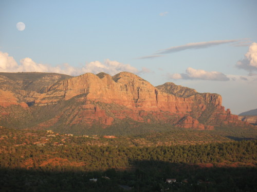
The Mermaid at moonrise, from Red Rock Loop Road

Honestly, you can find stirring scenery in Sedona, Arizona, without getting in a car and driving around. But spring is here, complete with wildflowers, busy birds, and blue skies, and one of the best ways to take it all in is with a scenic drive. Here are my favorites: 

1. Red Rock Scenic Byway
This 7.5-mile “All American Road” is Sedona’s main gateway, State Route 179 from I-17 through the Village of Oak Creek. Officially, Red Rock Scenic Byway begins at milepost 302, where SR 179 crosses Dry Beaver Creek. Like many “creeks” in Arizona, this one is a rocky wash except during spring runoff, but even when dry it’s delineated by tall cottonwoods and white-trunked Arizona sycamores. A couple miles further, the new forest service visitor center is an ideal place to stop to pick up trail maps and a Red Rock Pass, as well as take a long look at the panorama ahead. The view encompasses Bell Rock, Courthouse Butte, and other brilliantly colored cliffs.

In recent years, SR 179 has been widened to a divided four-lane highway, with scenic pullouts and ample trailhead parking. The designated scenic byway ends at milepost 310, near the celebrated Chapel of the Holy Cross, but the scenery doesn’t quit. SR 179 passes along Sedona’s “gallery row,” including the creekside shops at Tlaquepaque, before ending at “the Y,” a double-roundabout intersection with SR 89A.

2. Red Rock Loop Road
Travelers entering Sedona from the west via SR 89A can turn right at milepost 368 for Lower Red Rock Loop Road, the beginning of a scenic 7-mile long side trip that skirts the base of 4,899-foot Scheurman Mountain before circling back to rejoin the highway. Though a short section of the loop is gravel, the route is accessible to most passenger cars, depending on weather.

The loop road edges Oak Creek, where some of the Sedona area’s first settlers lived. The Schuerman homestead is preserved at Red Rock State Park, at mile 3 along the loop. The park offers great creekside birdwatching and easy hiking trails with great views. covered sandstone cliffs.

Don’t miss the side-trip to Crescent Moon Ranch picnic area and Red Rock Crossing. At the stop sign, turn onto Chavez Ranch Road and follow the signs. The spires of majestic Cathedral Rock soar above and reflect in the clear waters of Oak Creek, an inspiring scene said to be the most photographed place in Arizona.

The loop road climbs a series of hairpin turns before passing Red Rock High School and rejoining SR 89A. Dirt pullouts are good places to stop for breath-taking elevated views of Cathedral Rock and Courthouse Butte.

3. Boynton Pass Loop
A visit to Sedona’s backcountry, where you’ll find hiking trails and prehistoric ruins, begins by turning north on Dry Creek Road from SR 89A. Turn left at the next two T-intersections. (A right at the second T leads to the acclaimed Enchantment Resort and trailhead parking for Boynton Canyon, considered a vortex site.) The Boynton Pass Road (FR 152C) is paved to the Bear Mountain/Doe Mesa trailhead. Depending on weather conditions, most passenger cars can handle the dirt road beyond, which ends at FR 525, Red Canyon Road. Turn right, and you’ll come to a fork. To the left is the bumpy 4.5-mile route to Honanki ruins (high-clearance recommended). The 2-mile gravel road on the right leads to Palatki Heritage Site, home to a 900-year old dwelling built into the cliffs of Red Canyon by the Sinagua Indians. With a reservation, you can hike to the ruin overlook or take a guided tour through rock alcoves marked with thousands of pictographs and petroglyphs. Palatki and nearby Honanki are maintained by Coconino National Forest. To complete the loop after leaving Palatki, stay on Red Canyon Road for 10 miles until it connects with SR 89A.

BONUS: Schnebly Hill Road
Schnebly Hill Road winds up to the Mogollon Rim, following a historic route that early settlers used to reach Flagstaff, then a trip of 2-4 days. The views are amazing, but after the first mile, the dirt road is primitive and rocky. Unless you have a high-clearance vehicle, it’s best to see this one by signing up for a jeep tour or on foot via the Munds Wagon Trail, a 4-mile hiking trail that parallels the road. The trailhead has ample parking, picnic tables, and panoramic views of Uptown Sedona. Whether behind the wheel or on foot, stop to admire the Cow Pies, mounds of red sandstone (another vortex, say some) with outstanding views that take in Sedona and the Verde Valley. Schnebly Hill Road begins at the Oak Creek Bridge roundabout, next to Sedona Pottery.