Showing posts with label red rocks. Show all posts

Tuesday, January 15, 2013

Winter in Sedona

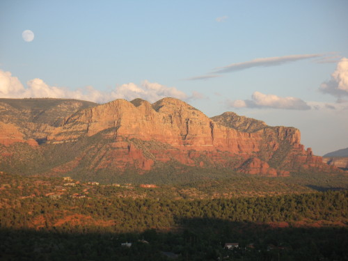
A storm breaks after leaving snow on Sedona's Capitol Butte.

During winter, the natural world seems to sleep. In Sedona, however, the winter months seem more like a magician’s spell. Autumn’s high tourist season is long past, and holiday visitors are gone. It’s this quiet, spellbound time that many of the town’s residents cherish as a chance to rest and reconnect with the attractions that inspired them to move here.

For visitors, this “off season” is a good time to rub elbows with locals and experience the natural world as it re-gathers energy for spring. And while the human social calendar is a bit thinner in January and February, Mother Nature continues to put on a show. Occasionally, snow dusts the tops of the red rocks, and sometimes a storm will blanket the forest floor, making it easier to see who’s been wandering the winter wonderland.

Tiny cloven prints a few inches apart belong to collared peccaries. Better known as javelinas, they forage in neighborhoods during winter months, parents and older sibs protecting the younger ones. Javelinas can reproduce year-round, and though most babies are born to coincide with the summer monsoon, two tiny brown-and-pink “piglets” showed up in my neighborhood in December. The precocious piggies trot along with the rest of the family band shortly after birth. Another morning, I watched nine mule deer cross the street and head into the forest, and last week a bobcat paused in the driveway. The ground is still damp from the last snowstorm, and trails boast a mosaic of prints.

Though days are short, the low angle of the sun sends rays deep into the alcoves where the prehistoric Sinagua Indians built their pueblos, and hikers may be surprised by the warmth of these original “passive solar homes.” In late afternoon, the setting sun burnishes Sedona’s red rocks, an especially dazzling sight if a breaking storm has topped the high peaks with snow, creating a contrast of light and dark, ice and fire. Nights are long and cold, but the air is crisp, and stars sparkle brilliantly.

By the end of January, nature is already beginning to stir. Manzanita and sugar bush show pink blossoms and buds in sunny locations, and green shoots mark future wildflowers. Sedona’s trails, always inviting, are lightly visited this time of year. Most of Arizona’s winter visitors tend to stick around the Sonoran Desert, where car auctions, the Phoenix Open golf tournament, and Scottsdale’s horse shows offer plenty of entertainment, and temperatures are a warm respite from harsher climates.

Sometimes, there’s a good reason to avoid visiting a popular location during the off-season, such as seasonal closures or unfriendly weather. But while Sedona’s winter weather is 10 to 20 degrees colder than the lower Sonoran Desert, it’s still relatively mild year round. Winter visitors to Red Rock Country will find Groupons or discounts on hotels and spa services, two-for-one restaurant specials, daytime highs around 50, and perhaps a dusting of snow.

In February the social calendar begins to pick up once more. The Sedona Marathon gets things moving on February 2, 2013, and five days later, Sedona’s first-ever yoga festival opens. By the end of the month, when the red carpet rolls out for the Sedona International Film Festival, daffodils and fruit trees are starting to blossom, and the town is already gearing up for spring break crowds.

Until then, Sedona rests quietly under winter’s spell….

Sunday, June 3, 2012

Take a Hike: Cathedral Rock


Cathedral Rock Trail is a classic Sedona hike.

Cathedral Rock, a monumental red sandstone formation in the center of the Sedona area, is one of the most-photographed scenes in Arizona. The classic view is along Oak Creek from the west, at Crescent Moon Ranch and Red Rock Crossing. (Scenic Red Rock Loop Road leads to this day-use area, a great spot for a picnic or a gentle stroll along the creek.) 

But it’s possible to climb to the very heart of the Cathedral’s sandstone spires, beginning from the formation’s northeast side. Some people say that the spires are where Cathedral’s vortex energy is concentrated. If you’re curious about Sedona’s vortex sites, a hike here is the perfect opportunity to see for yourself if all the buzz about Sedona’s special energy is mere hype or a genuine phenomenon.

For the trailhead, drive south on State Route 179 from its intersection with State Route 89A. At 3.5 miles, turn right at Back O’ Beyond Road and continue a half-mile to the parking area on the left. If you’re afraid of heights or unsteady on your feet, think twice about making this moderately difficult hike. Though it’s a mere 1.5 miles round-trip, it’s steep, with ledges and toeholds in some places. In places, the trail travels over bare slickrock; the forest service has marked the route with numerous rock cairns.

Once you arrive at the top, you can enjoy the views of the Chapel area to the east. Look for the two red rock spires known as The Nuns. To the west, Oak Creek’s meandering route is marked by a green band of trees that turn gold in autumn. A short scramble south leads to the base of the tall spire in the center of Cathedral Rock, known as The Mace. Do you feel the vortex vibe? Or is it simply the exhilaration of making an invigorating hike to an amazingly beautiful place?

Friday, March 30, 2012

Sedona's Top 3 Scenic Drives

The Mermaid at moonrise, from Red Rock Loop Road

Honestly, you can find stirring scenery in Sedona, Arizona, without getting in a car and driving around. But spring is here, complete with wildflowers, busy birds, and blue skies, and one of the best ways to take it all in is with a scenic drive. Here are my favorites: 

1. Red Rock Scenic Byway
This 7.5-mile “All American Road” is Sedona’s main gateway, State Route 179 from I-17 through the Village of Oak Creek. Officially, Red Rock Scenic Byway begins at milepost 302, where SR 179 crosses Dry Beaver Creek. Like many “creeks” in Arizona, this one is a rocky wash except during spring runoff, but even when dry it’s delineated by tall cottonwoods and white-trunked Arizona sycamores. A couple miles further, the new forest service visitor center is an ideal place to stop to pick up trail maps and a Red Rock Pass, as well as take a long look at the panorama ahead. The view encompasses Bell Rock, Courthouse Butte, and other brilliantly colored cliffs.

In recent years, SR 179 has been widened to a divided four-lane highway, with scenic pullouts and ample trailhead parking. The designated scenic byway ends at milepost 310, near the celebrated Chapel of the Holy Cross, but the scenery doesn’t quit. SR 179 passes along Sedona’s “gallery row,” including the creekside shops at Tlaquepaque, before ending at “the Y,” a double-roundabout intersection with SR 89A.

2. Red Rock Loop Road
Travelers entering Sedona from the west via SR 89A can turn right at milepost 368 for Lower Red Rock Loop Road, the beginning of a scenic 7-mile long side trip that skirts the base of 4,899-foot Scheurman Mountain before circling back to rejoin the highway. Though a short section of the loop is gravel, the route is accessible to most passenger cars, depending on weather.

The loop road edges Oak Creek, where some of the Sedona area’s first settlers lived. The Schuerman homestead is preserved at Red Rock State Park, at mile 3 along the loop. The park offers great creekside birdwatching and easy hiking trails with great views. covered sandstone cliffs.

Don’t miss the side-trip to Crescent Moon Ranch picnic area and Red Rock Crossing. At the stop sign, turn onto Chavez Ranch Road and follow the signs. The spires of majestic Cathedral Rock soar above and reflect in the clear waters of Oak Creek, an inspiring scene said to be the most photographed place in Arizona.

The loop road climbs a series of hairpin turns before passing Red Rock High School and rejoining SR 89A. Dirt pullouts are good places to stop for breath-taking elevated views of Cathedral Rock and Courthouse Butte.

3. Boynton Pass Loop
A visit to Sedona’s backcountry, where you’ll find hiking trails and prehistoric ruins, begins by turning north on Dry Creek Road from SR 89A. Turn left at the next two T-intersections. (A right at the second T leads to the acclaimed Enchantment Resort and trailhead parking for Boynton Canyon, considered a vortex site.) The Boynton Pass Road (FR 152C) is paved to the Bear Mountain/Doe Mesa trailhead. Depending on weather conditions, most passenger cars can handle the dirt road beyond, which ends at FR 525, Red Canyon Road. Turn right, and you’ll come to a fork. To the left is the bumpy 4.5-mile route to Honanki ruins (high-clearance recommended). The 2-mile gravel road on the right leads to Palatki Heritage Site, home to a 900-year old dwelling built into the cliffs of Red Canyon by the Sinagua Indians. With a reservation, you can hike to the ruin overlook or take a guided tour through rock alcoves marked with thousands of pictographs and petroglyphs. Palatki and nearby Honanki are maintained by Coconino National ForestTo complete the loop after leaving Palatki, stay on Red Canyon Road for 10 miles until it connects with SR 89A.

BONUS: Schnebly Hill Road
Schnebly Hill Road winds up to the Mogollon Rim, following a historic route that early settlers used to reach Flagstaff, then a trip of 2-4 days. The views are amazing, but after the first mile, the dirt road is primitive and rocky. Unless you have a high-clearance vehicle, it’s best to see this one by signing up for a jeep tour or on foot via the Munds Wagon Trail, a 4-mile hiking trail that parallels the road. The trailhead has ample parking, picnic tables, and panoramic views of Uptown Sedona. Whether behind the wheel or on foot, stop to admire the Cow Pies, mounds of red sandstone (another vortex, say some) with outstanding views that take in Sedona and the Verde Valley. Schnebly Hill Road begins at the Oak Creek Bridge roundabout, next to Sedona Pottery.

Thursday, February 23, 2012

Cinematic Sedona


Cathedral Rock appeared in Broken Arrow

This week, Sedona hosts its eighteenth annual International Film Festival, when more than a hundred movies unreel around town. It’s a fabulous event, and a wonderful time to be here, when bleary-eyed movie-goers can step from the theater into bright sunshine and the promise of spring, with fruit trees and daffodils blossoming around West Sedona, and wildflowers beginning to show up along forest trails.

Film buffs who are new to Sedona might feel a sense of déjà vu when they take in the local red rock landscape. No wonder, since more than eighty movies have been made in the Sedona area, many of them during the golden age of Westerns. For years, a Western town set stood in West Sedona (where a housing development is today), appearing in several films, including John Wayne’s Angel and the Badman (1946). A local hotel (now home to the wonderful Elote Café) was once the site of a soundstage. The area around Bell Rock (now the Village of Oak Creek) made a dramatic backdrop for The Rounders (1964) and other films, and the area of the Broken Arrow Trail was a key location in—you guessed it-- Broken Arrow (1950), starring Jimmy Stewart. 

Even today, traffic occasionally comes to a standstill while cameras roll for a commercial, television episode, or feature film. Every couple years, rumors surface about building a movie museum here, but for now, the best place to learn about the area’s Hollywood past is at the Sedona Heritage Museum, where an entire room is dedicated to Sedona’s cinematic history

The film festival usually includes a few local filmmakers, some of them students at Sedona's Zaki Gordon Institute. A few years back, I worked on a film script for producer/director RJ Joseph. It was quite a thrill to sit in a dark theater and hear my words during Che Ah Chi, a visually stunning documentary about the Native American history of Boynton Canyon, today home to Enchantment Resort


Sedona's film festival continues through Sunday, February 26. See you at the movies!

Tuesday, February 21, 2012

Sweet Home Sedona


Sedona, Arizona
On most any given day in Sedona, Arizona, visitors outnumber residents. Each afternoon, scores answer the seductive call of red sandstone to scramble up slickrock slopes in search of a vortex or view. Hundreds more drive up Airport Mesa or down Red Rock Loop Road to snap photos of rocks shaped like castles, critters, and kitchen implements. Shoppers jaywalk through Uptown, mountain bikers bomb down forest trails, and drivers—visitors and locals alike—hit the brakes when something unexpected crosses the road, be it a family of Gambel quail or a hot-air balloon gone astray.
            Life here can get pretty wacky at times. Maybe it’s because Sedona’s red rocks are riddled with vortexes (vortices, if you prefer). Whether they are whorls of energy or inventions to attract tourists, their draw is second only to the landscape itself. But more about the vortex scene another time. First, let’s consider Sedona’s other-worldly landscape, the reason why so many people (1) visit here, (2) move here, or (3) fantasize about moving here.
           The greater Sedona area, home to about 15,000 people, encompasses Uptown, West Sedona, and the Village of Oak Creek. It’s a bit like a suburb without an urb, a commercial/residential island surrounded by a sea of public land, most of it Coconino National Forest. Neither desert nor mountain but somewhere in between, the Sedona area is situated a couple thousand feet below the southern edge of the Colorado Plateau. Rugged canyons—splendid for hiking—are carved from the plateau’s Permian rocks. One, the canyon of Oak Creek, cuts through a 2,500-foot geological layer cake on its 12-mile length, revealing an earth shaped by oceans, deserts, swamps and volcanic flows.
           Sedona’s famed buttes and spires are sculpted from a 700-foot thick stack of mudstone, sandstone, and limestone colored dark red, orange, and gray. In some places, limestone forms a hard cap that protects lower, softer layers of rock, leaving water and wind to create shapes that tease the imagination. Taller peaks, like Bear Mountain and Capitol Butte, are topped with a gorgeous golden cross-bedded sandstone formed from ancient dunes. Counterpoint to the red and gold rocks is a patchwork of green (mostly piñon and juniper) and intensely blue skies.
           Living in such a beautiful place can be both blessing and curse. On days when deadlines keep me at my desk and a quick dash to New Frontiers for groceries becomes a protracted battle to find a parking space among hordes of rental cars, I grit my teeth to see the drivers lounging at the tables outside the deli, sipping wheatgrass shakes or lattes. Mildly sunburned and smiling, wearing Tevas and shorts, they consult topos or phone apps to plan their next adventures. As for me, well, I am as jealous as a jilted lover.
           My green-eyed monster may violate Sedona’s New Age vibe, but the sin of envy makes sense if you agree with one of my favorite writers, Pico Iyer, who compares travel to a love affair. He points out that travel is “a heightened state of awareness in which we are mindful, receptive and ready to be transformed.” 
           Travelers--and lovers--fare best when they are open to the unexpected and willing to become lost. This state is familiar to Buddhists and yogis as beginner’s mind. Lovers know it as the discovery stage, when all seems magical and possible. Psychologists might call it infatuation or limerance. Here in Sedona, we've dubbed it Red Rock Fever, and it can make people do foolish things, like trying to hike up Bell Rock in flip-flops or abandoning a steady career to become a yoga teacher or tour guide. (Or travel writer.)
           Being a travel writer, I get to fall in love a lot. And though it may be a bit harder to drum up passion for the familiar, state of mind is quite portable, as easy to pack as a clean pair of socks and ready to go anywhere … even the grocery store.